Waiheke Island Transport Design Guide Waiheke Island Transport Design Guide
The Waiheke Local Board and Auckland Transport have worked together to create the Waiheke Island Transport Guide.
- Download the Waiheke Island Transport Design Guide (PDF 6MB)
- Give us your feedback
- Find out more about the guide
- View a list of additional resources
Design guide consultation
We asked you what is important to retain and enhance, and what is a priority to improve, on Waiheke Island with regards to transport and transport infrastructure.
This consultation is now closed. All feedback will be compiled, and the Feedback and Decisions Report will be available on this website. Submitters who have provided contact information will be kept updated.
Background
In 2017 AT and the Waiheke Local Board collaborated to establish a formal Memorandum of Understanding (MoU) to guide the relationship and enable greater alignment to achieve transport outcomes to meet Waiheke’s changing needs.
One of the key actions from the MoU was the development of Waiheke’s first collaborative, multi-modal 10-year transport plan – Waiheke 10 Year Transport Plan, adopted in 2020. The 10 Year Transport Plan contains a full, prioritised list of the 100 projects, plans, services and processes desired by the people of Waiheke to create a better transport system on the island.
The Waiheke 10 Year Transport Plan is consistent with the Waiheke Pathways Plan 2019, which promotes over 40 priority projects to improve walking, cycling and horse riding on Waiheke.
The development of a Waiheke specific design guide is identified within the 10 Year Transport Plan as a key priority and tool to create a greater degree of consistency and certainty, while reflecting the island’s character, in the upgrade of roads, footpaths and other transport infrastructure.
Why is this needed for Waiheke?
Waiheke Island is the second largest island in the Hauraki Gulf and the most populous. To accommodate the current and future population and visitor numbers, there is a need for major capital investment to improve the quality, safety and connectivity of the transport network on Waiheke, in particular the street/road network.
Census data used to create the Waiheke 10 Year Transport Plan indicates Waiheke has different travel behaviour to the rest of Auckland, with lower rates of private vehicle use and higher rates of walking or jogging and of cycling. Notably, over 70% of Waiheke’s children are driven to school with road safety concerns cited as the main reason for deferring walking and cycling.
Download the Waiheke Local Board Plan (PDF 4.3MB)
Road and street types and conditions in Waiheke have evolved differently to urban Auckland, in a piecemeal way due in part to topography and pace of development. As a consequence, there is a lack of consistent street design in type, character and condition.
At present the footpath and cycle network is piecemeal and fragmented. In many locations it is constrained by the island’s steep topography and roads. Safe transport is a primary objective in street design throughout Auckland.
Creating streets that protect and improve conditions for walking, cycling, horse riding and public transport not only encourages greater use for these modes, but improves resilience to climate change, aids Waiheke’s goal of becoming a low carbon community, and importantly contributes to the prevention of deaths and serious injuries for all road users as per AT’s Vision Zero goals.
For these reasons it is imperative that the island has safe and effective pedestrian infrastructure, linking people to village centres, schools, ferries, places of employment and recreational destinations.
Purpose of the guide
The purpose of the guide is to ensure the character of Waiheke is maintained and enhanced as the island adapts to its current levels of population and/or visitors, or contemplates changes either to reduce numbers or grow further, requiring the design of streets and places in a way that is safe for people who live, work or visit Waiheke.
The guide establishes a vision and set of guiding principles, developed collaboratively between AT and the Waiheke Local Board, for all transport designs on the island which recognise the specific character of Waiheke; who the expected users of the island’s roads, streets and pathways are; and how the various transport activities on the island’s various transport corridors can fit together.
The guide sets out how to design future streets and retrofit existing ones on Waiheke in a way that is safe and convenient for all users, while retaining Waiheke’s special character.
The guidance within this document establishes best practice. It does not provide the detail of engineering codes as these are set out in separate documentation.
Rules related to site access, parking and loading, helipads and airstrips are not included within this guide. These are addressed within the Auckland Council District Plan - Hauraki Gulf Islands Section, Part 13: Transport.
Application of the guide
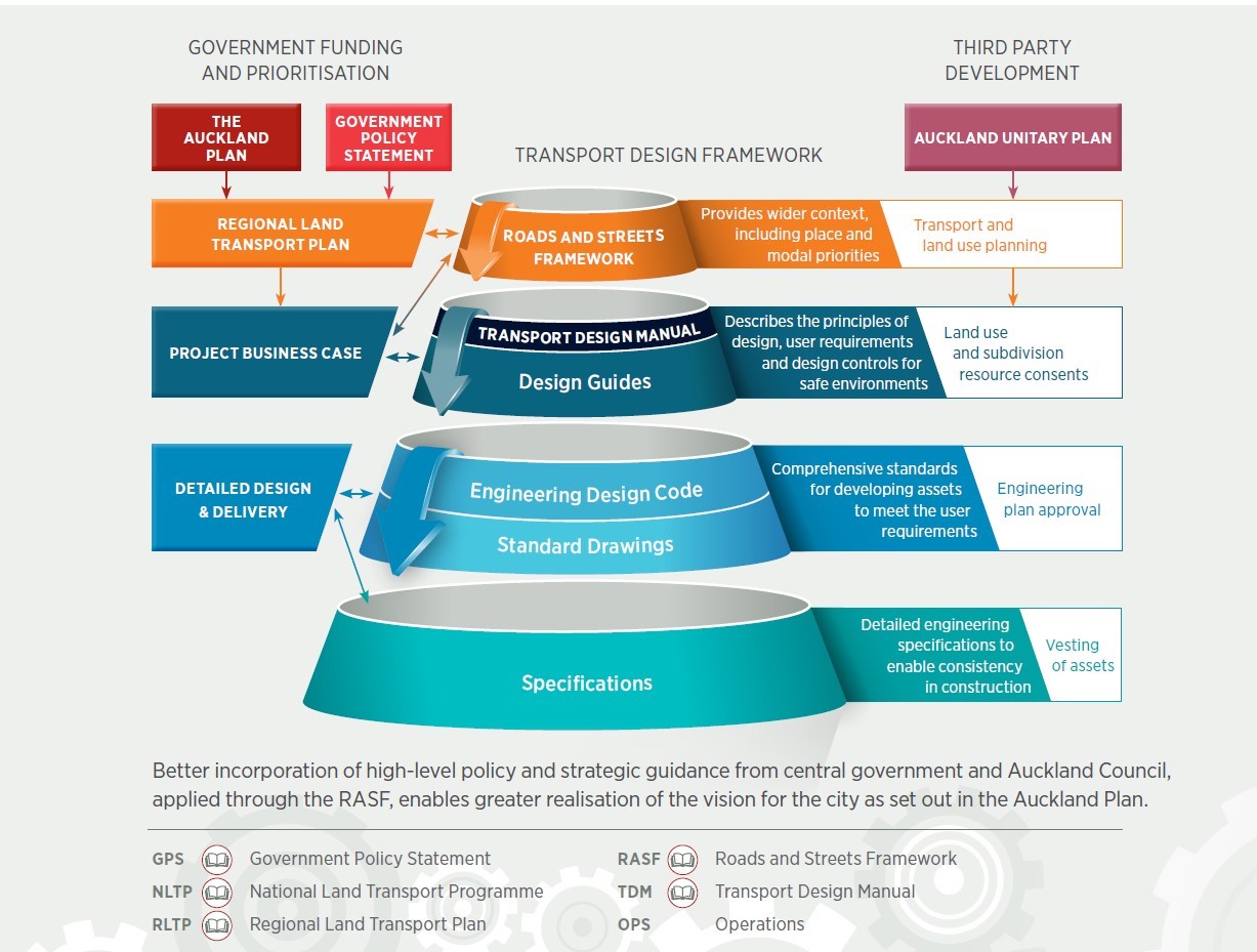
The Transport Design Manual is a set of guides, codes and specifications that are specifically created for the Auckland region based on integrating best practice and robust common engineering theory.
The Waiheke Transport Design Guide is a supplement to the Urban Street and Road Design Guide (USRDG) and other documents that sit within the Transport Design Manual. The purpose of this guide is to provide guidance on how to design changes to Waiheke’s transport infrastructure from the perspective of all road users, in particular the very young and the very old and therefore ensuring safe and people-friendly design. This guide does not replace this USRDG, but rather is intended to be used in conjunction with it to define and enhance the character of Waiheke when undertaking transport related works.
As stated in purpose above, this guide describes the environment, the principles of design, the needs of different road users and guidance for achieving safe environments while retaining or enhancing the character of Waiheke. Any solutions for the detailed design and delivery of transport infrastructure will be worked through collaboratively through the appropriate design phases.
Implementation – are improvements required?
Auckland Transport recognises that incremental minor alterations within Waiheke can cumulatively alter the character of the island. At the inception of any project very careful consideration will be given as to why the potential works are required.
This will include consideration of:
- Whether the works are necessary for the safety of all road users. The Safe System approach of promoting choice while planning for mistakes, designing for human vulnerability, strengthening all parts of the road transport system and shared responsibility must be used to inform design.
- Whether the works are necessary to improve the comfort of all road users.
- Whether the works will retain or enhance the existing character of the immediate environment.
- Whether the works could have a positive, neutral or negative impact upon the principles of the guide.
Vision and principles of the guide
The vision and principles were developed with the Waiheke Local Board and the Waiheke Island Transport Forum and set a long-term vision for transport on the island.
The guide seeks to preserve what makes Waiheke a unique place: its natural beauty combined with the island’s rural and village settings.
The vision is for a self-sustainable island that caters for the local community and becomes a destination for its unique environment, combining natural features and a relaxed lifestyle.
A place with opportunities accessed equitably by all its people, with a transport system that caters for visitors and the local community, particularly for the young, the elderly and those with mobility issues.
Waiheke is about vibrant places connected by a safe and sustainable transport system fit for our inclusive and eco-conscious community.
See page 12-13 in the full guide for more information
Te Aranga Māori design principles
AT and Waiheke Local Board are committed to the principles of Te Tiriti o Waitangi and working in partnership with mana whenua of Tāmaki Makaurau.
Te Aranga Maori design principles are included in the guide to provide a starting point for a three-way conversation between mana whenua, the Waiheke Local Board and AT to ensure that the values and cultural heritage of iwi and hapu as mana whenua who whakapapa to Waiheke are reflected in transport projects in a way that is meaningful to them.
See page 16 in the full guide for more information
Principles of the guide
These principles supplement those within the Urban Street and Road Design Guide (USRDG) to ensure transport projects maintain the character and sense of place that is intrinsic to Waiheke.
Protect & enhance the island’s natural beauty and biodiversity and ensure effects on ecological systems are minimised.
Te Tiriti o Waitangi - Include Māori in transport decision-making. Demonstrate respect for mana whenua values and Te Tiriti principles.
Accessibility regardless of age and/ or ability: everyone should expect easy use of transport corridors, safe and free movement.
Safety provisions are prioritised for all transport modes, in particular safe routes to school.
Connect people with schools, reserves and sport fields, and beaches by enabling walking, cycling and other outdoor activities in safe, accessible, and natural settings.
Preserve and highlight the aesthetic and scenic attributes and natural values of Waiheke with a context-sensitive design of transport projects.
Support economy of the island with transport systems attractive and accessible to both residents and visitors.
Future consideration in design and implementation that is low carbon and resilient to changes in travel demand/ mode and sea level rise.
Respect the island’s history, cultural and natural heritage, and mana whenua. Ensure transport works retain the Island’s rural/ semi-rural character.
Harmonise the guide’s vision and intent with standard practices and design and consider and implement adaptions as necessary to reflect these.
Maintain Waiheke’s desired ‘Dark Sky’ status and the island’s fauna by designing street lighting to minimise upward spill of light (where possible).
Use Local - where practical use low carbon footprint/ locally sourced high quality, durable, natural materials for transport infrastructure, seating and planting.
See pages 14-15 in the full guide for more information
Infrastructure sustainability principles
AT is developing policies and tools to ensure its assets are built and operated to contribute to restoring or enhancing the environment.
These tools are still in development, the following principles should be applied to any new transport project including on Waiheke:
- Reduce greenhouse gas (GHG) emissions throughout the lifecycle of assets
- Reduce the amount of waste produced and divert any waste from landfill
- Continue to minimise sediment entering waterways
- Provide opportunities for targeted groups experiencing barriers to employment
- Adopt a green infrastructure/ water sensitive urban design approachProvide opportunities for Māori and Pasifika businesses, social enterprises and socially innovative businesses
- Reduce amounts of materials used and look for opportunities to substitute with recycled materials
- Understand and have measures in place to address the predicted impacts of climate change
- Actively minimise any sedimentation from entering waterways
For more information on these sustainability principles, please refer to AT’s Infrastructure Sustainability Guidelines.
Movement to and around Waiheke
All transport modes and objectives were considered in developing the guide:
- People on foot: Safe footpaths and pedestrian connections.
- People with accessibility needs: Connected footpath network, with pedestrian crossings and audio/ digital real-time information at bus stops. Footpaths with a minimum clear path width of 1.8m (where possible).
- People on horses: Horse riding as a mode of transport is provided for within the guide, recognising that paths may be on or off the road network.
- School children: 70% of children are driven to school due to current lack of dedicated footpaths. Safe routes to school are a priority.
- People on bicycles: Make cycling a safe and more viable option, particularly for shorter trips.
- Freight: Freight trips are expected to increase with a growing population. Increased freight movement places increased pressure on the existing road network and requires safe, dedicated routes.
- People on buses: Buses provide access to and connections between major destinations and need to be able to safely use the road network and people travelling by bus need to be safe.
- Wharves and ferry services: Waiheke’s wharves act as important local transport interchanges between sea and land travel for residents and visitors alike. They should provide appropriate infrastructure for arrival, and visual and textural cues on the landward side will support safety and accessibility.
See pages 19-21 in the full guide for more information
Streets and Roads – Type and character
The following section sets out the existing street types and character as articulated in the Waiheke Island Pathways Plan with the addition of streets exhibiting particular characteristics such as the village centres or beachfront streets.
Village centres and beachfront streets are locations that have higher volumes of pedestrians than the typical typology (arterial and/or collector road) and may warrant different treatment as a result.
As with any locality, a variety of street types must work together in a local context to create lively and thriving places, balancing the various and competing needs of movement and place as one type intersects or merges with another.
Roads and streets framework
The Auckland Transport Roads and Streets Framework (RASF) provides a consistent methodology for identifying the place and movement functions of roads and streets. It is designed for use on both existing and new roads and streets to determine the function of roads and establish modal priorities.
It is aligned with Waka Kotahi NZ Transport Agency’s One Network Framework (ONF). This new approach to place and movement outlines the regional significance of the street in terms of its role in the wider Auckland transport network.
See page 26 in the full guide for more information
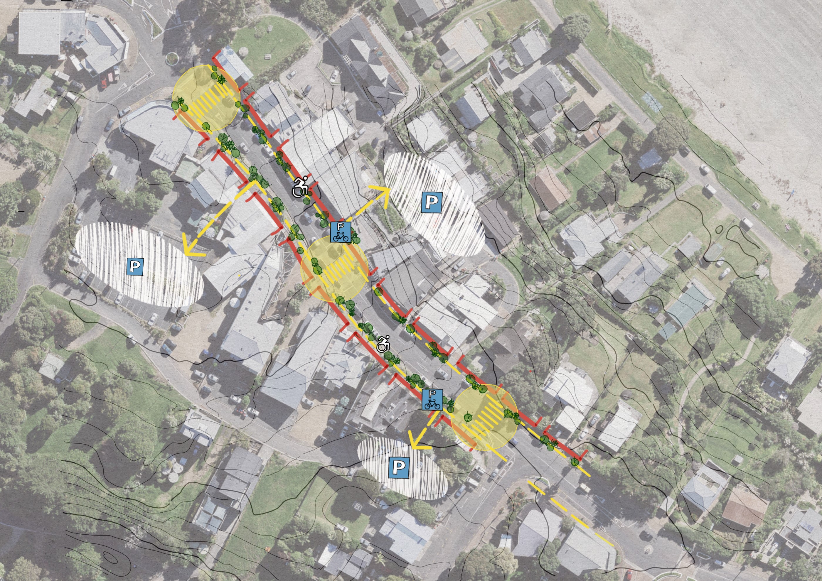
Village Centres
The main streets through the villages on Waiheke need to prioritise safety and accessibility for people walking to local shops, services, cafes and restaurants, and those using public transport.
As key destinations these also need to provide areas for vehicular and cycle parking to support local businesses.
Existing issues:
- Footpaths not continuous, varying widths and often on different levels to the street, impacting on accessibility for those less able
- Lack of safe, well-located crossings connecting both sides of the street, particularly around bus stops
- Traffic speed variable which can impact on pedestrian safety
- Inconsistent provision or lack of dedicated cycle facilities
Guidance for village centres includes:
- Threshold treatments for ‘slow’ zones
- Signage and wayfinding
- Bus stop and shelter locations
- Pedestrian crossing and continuous footpaths
- Accessibility treatments
- Street furniture, lighting and planting
- Cycle network and parking
- Vehicle parking management
Illustrative treatment for a village centre: (Based on Oneroa). Thresholds, crossings, active frontage, parking areas behind shops with pedestrian connections to the main street, street trees and mobility access.
See pages 27-29 in the full guide for more information
Arterial Roads
Arterial routes connect all the major settlements and destinations throughout the island. This route has a high movement function and requires journey reliability for buses, freight and commuter traffic.
Existing issues:
- Pedestrian and cycle safety on high(er) speed roads, in particular safe crossing locations connected to bus stops
- Unconnected footpaths (often absent or only on one side of road)
- Intermittent and unconnected cycleways (also poorly maintained
Guidance for arterial roads includes
- Street names and speed limiter signage
- Bus stop locations and layout
- Bus shelter designs
- Accessibility treatments/infrastructure
- Pedestrian crossings and footpaths/boardwalks
- Footpath lighting (minimising light spill)
- Footpath surface (red-brown colour, surface recognisable for low/no vision persons)
- Cycleway design with separators (further work required for limited space locations)
- Planting and street trees
Indicative treatment for an arterial road: Bus stop, clearly delineated pedestrian and cycleway protected from carriageway by separators. Two lane carriageway at 50km.
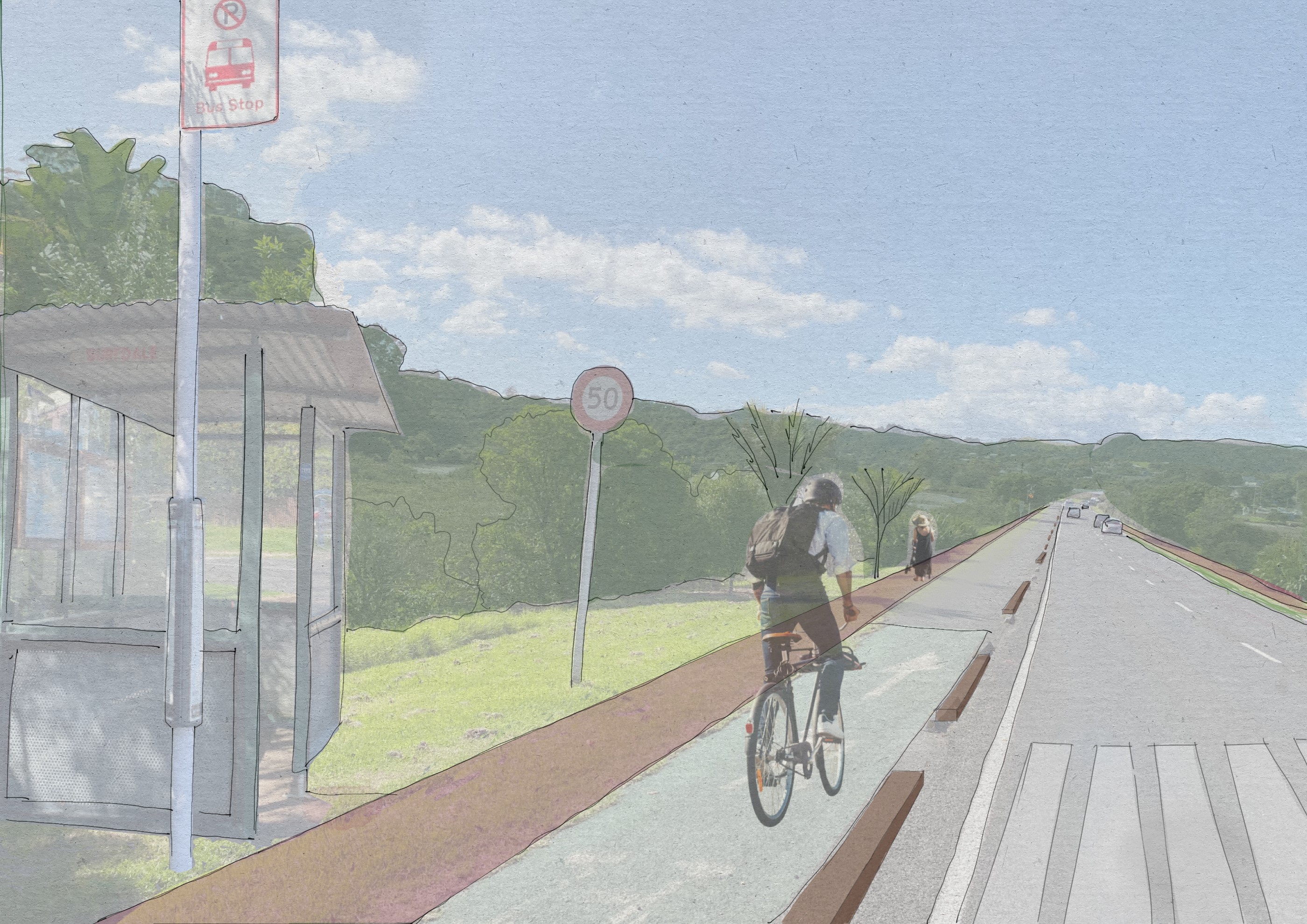
Indicative cross section for an arterial road: This can be varied on narrow lengths of road with cycleway or footpath only on one side of the route.
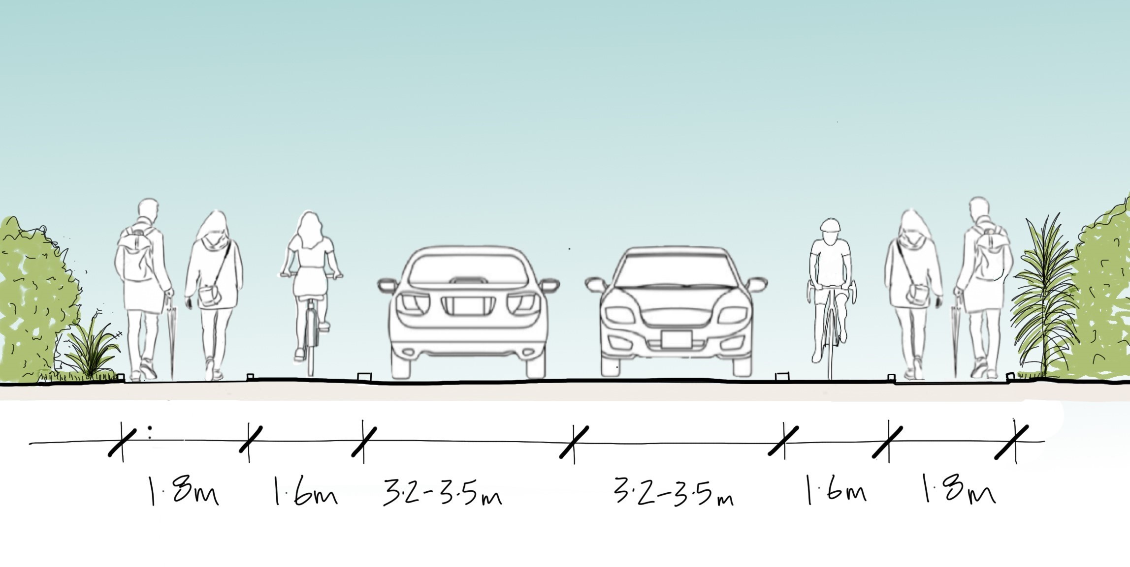
Please note: This is just an example. Each construction project will undergo their own design process considering available road width, topography, etc.
See pages 30-32 in the full guide for more information
Beachfront Roads
Access to the beach is an inherent part of life on Waiheke. Conflicts arise where motorists and vehicles impede on safe access for pedestrians to and from the beach.
Existing issues:
- Narrow or no footpath adjacent to road (in formal road locations)
- Sleepers used as wheel stops in informal situations to protect pedestrians with mixed results
- Vehicles parked on pedestrian areas
Guidance for beachfront roads includes
- Threshold treatments for ‘slow’ zones
- Pedestrian access and priority
- Footpath separation and accessibility
- Parking management (including mobility parking)
- Parking restrictions on beach side for safety and beach protection
- Convenient cycle parking
- Bus stop locations and accessibility of beach access
- Turn-around areas for vehicles including buses
Indicative treatment of a beachfront road: Informal demarcated footpath between road and beach, narrow carriageway to encourage slow speeds, no parking lines, except for mobility parking.
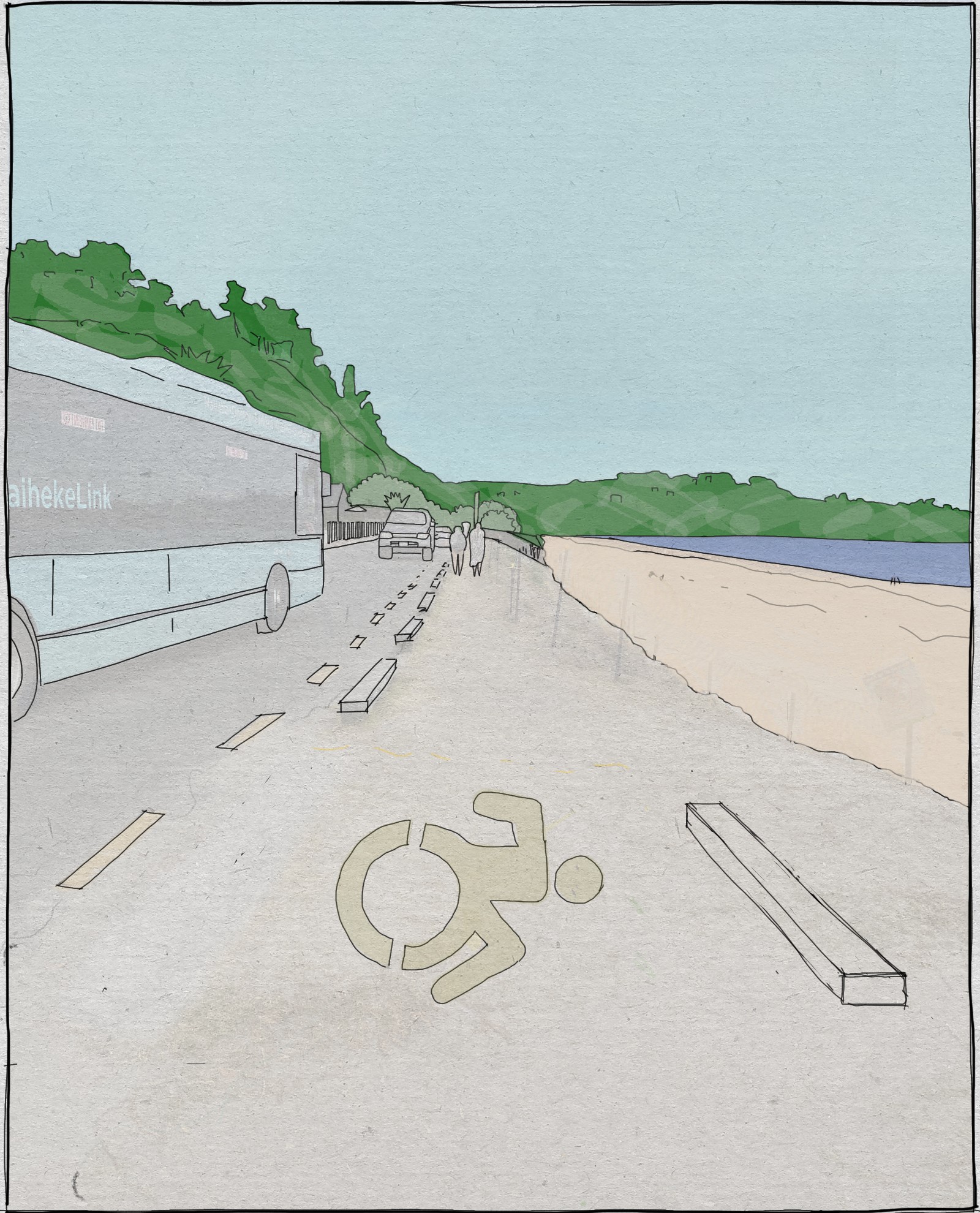
Please note: This is just an example. Each construction project will undergo their own design process considering available road width, topography, etc.
See pages 33-35 in the full guide for more information
Collector Roads
Collector roads are significant for locals and visitors as they provide connections between key destinations and residential locations.
In many places, the undulating topography has resulted in dwellings are either above or below the street, limiting space to retrofit footpaths or cycleways in the current road design.
Existing issues:
- Most streets lacking defined / continuous footpaths, where footpaths exist, narrow red chip with kerbs, otherwise informal grass verges adjacent to the road
- Limited or no dedicated cycle infrastructure
Guidance for collector roads includes
- Design reflecting Safe Speeds
- Bus stop locations and shelter design
- Pedestrian crossings and continuous footpath (narrowing road in some places to allow)
- Downhill footpaths on hilly terrain with separators
- Silt fence rocks and planting to manage run-off and drainage
- Red/brown footpath surface colour
- Sharrows where space insufficient for separated cycling facilities
- Off-street parking required for dwellings (or other alternatives)
Indicative treatment of a hilly collector road: 1.8m wide footpath on downhill side of road, 6m carriageway (up to 6.4m carriageway width on bus routes). 30kmph speed limit and sharrows for bicycles.
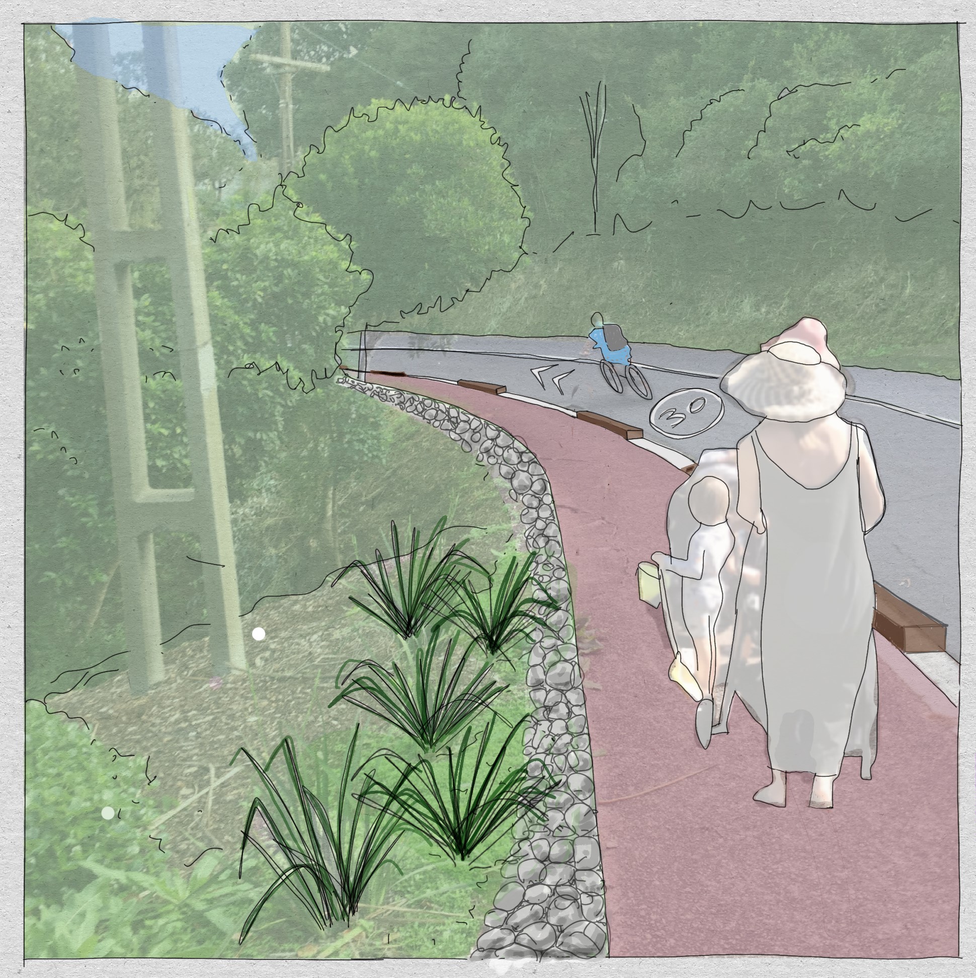
Indicative cross section of a hilly collector road: with protected footpath and stormwater management.
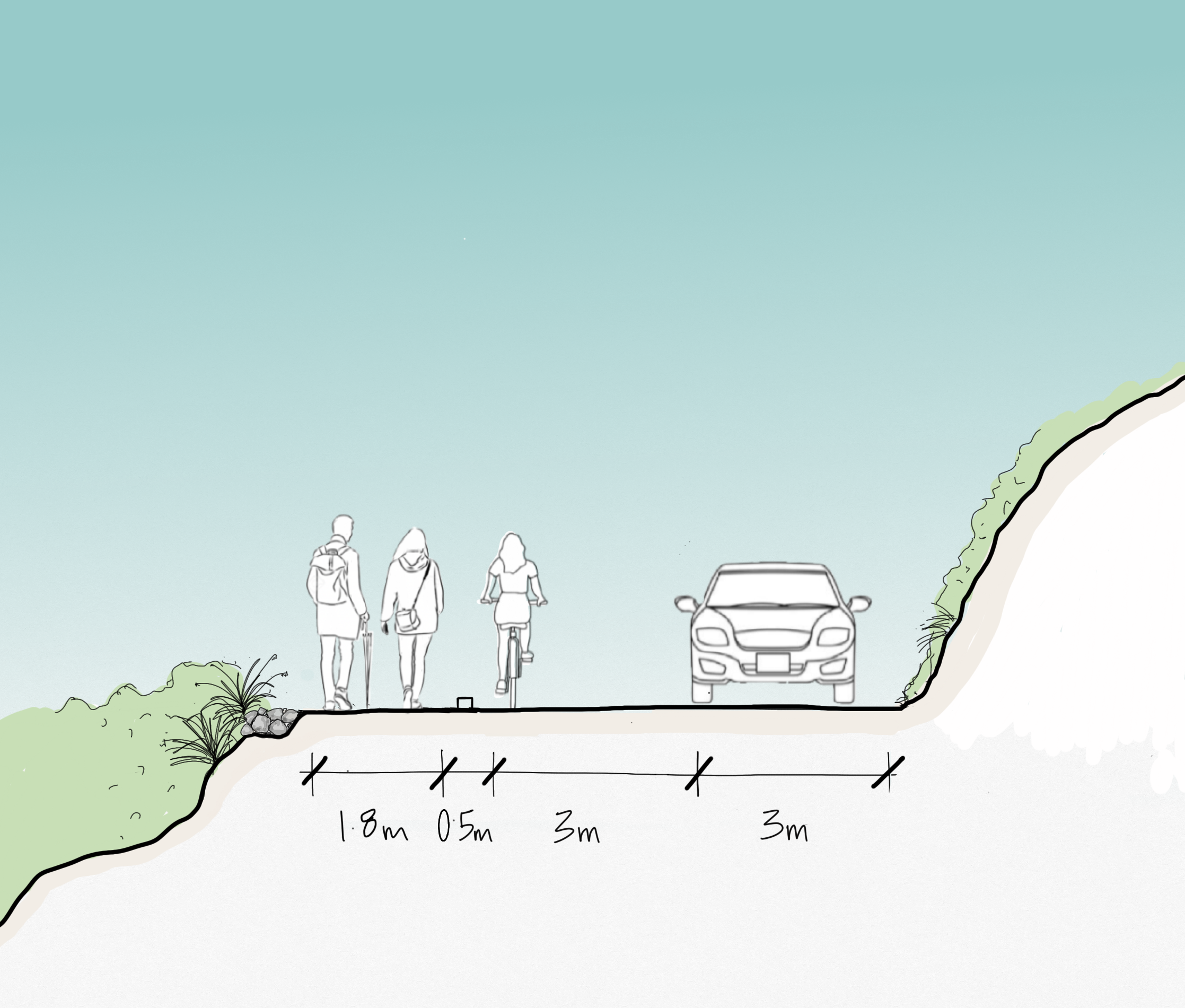
Please note:This is just an example. Each construction project will undergo their own design process considering available road width, topography, etc.
See page 36-38 in the full guide for more information
Local Roads
Local streets and roads possibly demonstrate the greatest variance in width and treatment. Some have two lanes while others are narrow, single lane roads. Some of the local streets have wide grass verges, while others have little or no verges requiring pedestrians, cyclists and horse riders to share the road with motorists. Some streets have capacity for off-street parking, while others have very little.
The key message for local streets and roads is ‘share with care’. The emphasis should be on safe routes for pedestrians, cyclists and horse riders.
These roads require minimal intervention, however the guide recognises there are two specific types of local streets.
Guidance for local roads includes
- ‘Share with care’ principle with signage
- Threshold treatments with planting/texture could be used to calm traffic
- Slower speed encouraged
- Off-street parking required for dwellings (or other alternatives)
Suburban local streets
Often close to village centres and/or beaches, often with verges
- Slow speed environments with narrow carriageways (2.7m each side) on the two-way streets
- Where possible, verges have 1.5m (minimum) level, all-weather strip on at least one side for pedestrians
Single-lane roads
Often with no road markings and no verge, and some unsealed
- ‘People first’ principle on single-lane roads
- Low impact solutions encouraged for road surface and stormwater treatments
See pages 39-40 in the full guide for more information
Off-road Pathways
The lack of formalised roads with footpaths has led to several off-road routes and greenways through parks and open spaces throughout Waiheke.
These connect streets to streets, often on generous paths, free of conflict with vehicular traffic and generally all-weather surfaces.
Off-road pathways need to be safe for all users and increase permeability and connectivity between locations by foot and, where practical, by cycle, micro-mobility device, and horse.
They need to be accessible, with clear lines of sight and, in high-volume locations, include lighting for safety.
Guidance for off-road pathways includes
- Public pathways connecting streets, roads to school, or coast and centres, through green space along beaches or unformed roads should be preserved and enhanced to become Traffic Free Routes (TFRs) as safer alternatives to routes located within road reserves
- Clear signage and wayfinding including accessibility
- Opportunity for formalise tracks to expand or connect the wider network
- Upgrade paths to 3m wide where practical and have all-weather surface (in Waiheke path red/brown)
- Vegetation management for better access/ visibility
- Where possible, a separate path along the route for cycles and horses
See page 41 in the full guide for more information
Rural Roads
Rural roads provide access to rural properties and rural production as well as routes to many of Waiheke’s tourist destinations.
The roads support a mix of traffic types including farm vehicles, freight, local and visiting motorists, cyclists, people on horses, and the occasional pedestrian.
The roads require regular seasonal grading and maintenance, particularly during the busy summer months, to ensure they are roadworthy for all vehicles.
These rural roads offer some noteworthy views over the landscape and to the coast/Hauraki Gulf, acknowledged by the bench seats that denote scenic lookout locations, that attract people to park on the roadside to take in the view.
Existing issues:
- Heavy farm traffic conflicting with visitor traffic on unsealed roads
- Increase in freight traffic impacting on the quality of the road surface and ability to absorb heavy rainfall
- Lack of walking infrastructure on or adjoining rural roads
- Lack of safe parking for scenic lookout locations
Guidance for rural roads includes
- Where a road warrants sealing, retain carriageway width of 6-6.4m
- Maintain informal edge treatment when sealing, with swales or similar for retention and stormwater treatment
- Establish wide grass verges with level terrain for walkers and cyclists avoiding heavy vehicles
- Low-impact (gravel) pull-in parking bays at scenic locations for cyclists, motorists and tour buses
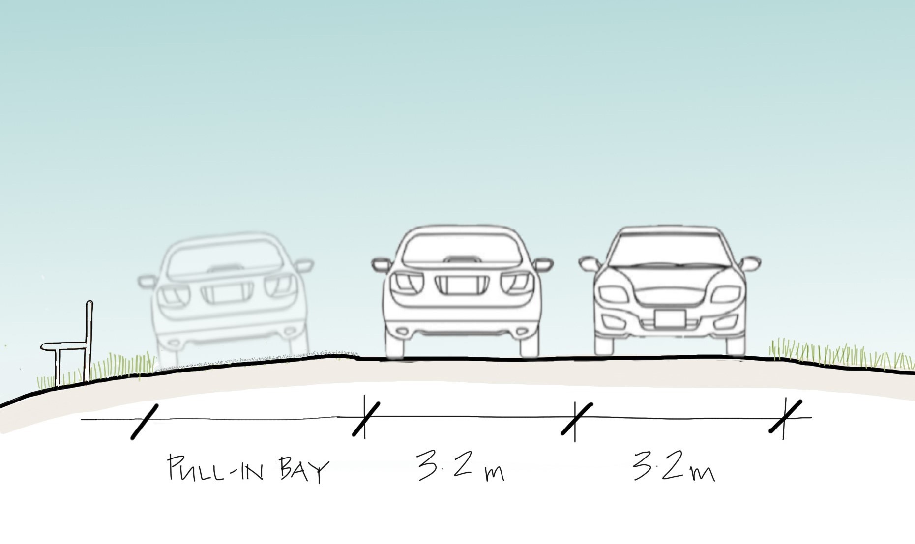
See pages 42-43 in the full guide for more information
Other elements of the transport network
Wharves as transport hubs, and designs for accessibility and aesthetics regarding bus stop and shelters, seating, lighting, signage and pathways, planting and vegetation, and stormwater management also feature in the guide.
Wharves as transport hubs
Waiheke’s wharves provide important local interchanges between sea and land travel for residents and visitors alike.
Ideally, these interchanges enable people to move easily between modes of transport.
The needs of people travelling to, from, and around Waiheke, as well as safety and accessibility, should inform the provision of services and facilities of the wharves.
Matiatia provides dedicated bus stops, a taxi rank, cycle parking and a high level of service for ferry passengers. In the future it must enable more active transport mode shifts and the best public transport access feasible, along with seamless visitor or local transit options.
Guidance for wharves as transport hubs include:
- Clear wayfinding signage, including tactile pavers
- Bus stops and mobility drop-off points easily accessible and visible
- Sheltered waiting areas
- Waiting facilities (toilets, rubbish bins, seating, ticketing, commercial facilities)
- Open-plan design for visibility
- Universally accessible footpaths to and from the next transport mode (in particular bus stops)
- Short-term parking where space allows, while prioritising safe pedestrian movements and bus access
- Emphasis on Park n Ride facilities close to centres and terminals
- Low-impact surfacing of parking areas (gravel or suitable permeable surface treatment)
See pages 46-47 in the full guide for more information
Bus shelters
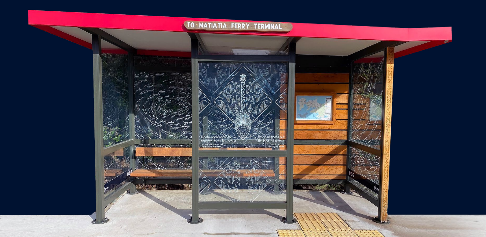
Waiheke’s distinctive, eclectic and quirky bus shelters are part of the character of the island.
Although a variety of style, the bus stops tend to all be painted a deep olive green with red trim on the roof, making them stand out as operational bus shelters.
In 2019/2020 AT and the Waiheke Local Board and mana whenua developed a new, specifically designed bus shelter with designs by local artist Sally Smith and Ngāti Paoa artist Michael Paki, in tandem with new bus routes.
Guidance for bus shelters includes
- Where a road warrants sealing, retain carriageway width of 6-6.4m
- Retain Waiheke’s unique and often bespoke bus shelters, where practicable
- New shelter design where a new shelter is deemed necessary
- Bus shelter signage, visibility, and accessibility for all
- Relocate and reuse unused shelters in more constrained locations
- Shelters to have timetable and routes information attached or adjacent
- Retrofit shelters with digital real-time information, wherever practicable, on frequent service routes
- Shelters free of external advertising material
- Care with bus stop/cycle lane conflicts to design mitigating potential collision risk
New shelter design: Waiheke specific bus shelter design approved in 2019/2020.
See pages 48-49 in the full guide for more information
Seating
Public seating provides opportunities for rest and respite, and enjoyment of views.
Waiheke also has a distinctive style of public seating – primarily either a plain bench or with a back, with a rustic, local, coastal appearance.
Guidance for seating includes
- Retain Waiheke’s distinctive public seating
- For required new seating, use Waiheke’s rustic benches with back support and arm rests
- Seating located in safe, visible locations to provide rest and/or take advantage of views
- Wherever practicable, secure seating over grass or planting.
Typical Waiheke seating

See page 50 in the full guide for more information
Lighting
AT recognises the unique character of Waiheke and in particular the eastern half’s semi-rural nature, which is part of the International Dark-Sky movement (IDA) which safeguards the night skies for present and future generations.
Some roads and streets need to be lit for safety of all road users, and lighting on pedestrian paths or at bus stops is required to give a sense of safety and visibility.
Guidance for lighting includes
- Road lighting designed to minimise light spill
- Install pedestrian scaled lighting where required for pedestrian safety
- Where possible, use motion detector lights around bus stops (instead of constant light)
- Use the lowest light level required for safety, and warmer colour LED lights
- Consider reflective paints or self-luminous markers for signs and kerbs (instead of street lights) on local streets within rural residential parts of the western side of the island
See page 51 in the full guide for more information
Signage and road markings
Too many signs create clutter, cause distraction and detract from sense of place and can impact on views.
Conversely reducing road signs and markings can passively calm traffic by encouraging road users to take their cues from the design from the environment to determine appropriate travel speeds.
Signage and road marking guidance includes
- Waiheke-specific design for road signs including appropriate colours and materials, such as the wayfinding signage for the Te Ara Hura walkway (below)
- Where new signs are required, the agreed signage will be used
- Use local materials such as sleepers and posts for signage posts, or attach to light poles or telegraph poles
- Co-locate road signs with information signs wherever possible (minimise visual clutter)
- In residential areas incorporate community-led art elements into signage
- Consider changes in road surface treatment instead of markings painted on the roads
Typical Waiheke signage

See page 52 in the full guide for more information
Planting and vegetation
Waiheke has several areas of regenerating coastal forest.
The aim of planning within the road reserve should be to recreate that sense of a coastal forest and support biodiversity on the island.
This approach aligns with Auckland Council’s Urban Ngahere Strategy.
The nine principles of the Urban Ngahere Strategy are:
- Right tree in the right place
- Preference for native species
- Ensure urban forest diversity
- Protect mature, healthy trees
- Create ecological corridors and connections
- Access for all residents
- Manage urban forest on public and private land
- Deploy regulatory and non-regulatory tools
- Manage the whole lifecycle of urban trees
Planting and vegetation guidance includes
- Suitable indigenous species selected from the tables (page 55 of the full guide) so planting supports biodiversity and an urban-coastal forest
- Wherever possible, adopt a ‘design with nature’ or Water Sensitive Design (WSD) approach to stormwater management to preserve or restore natural overland flow paths
- Use street trees and low vegetation to intercept stormwater and slow its flow
Note that not all of the species in the table will be suitable for the specific conditions of each location. Advice should be sought at a more detailed design phase to determine appropriate species and size for the situation and the ongoing maintenance requirements.
For management of pest plant species within the road reserve, refer to the Waiheke Ecological Restoration Works Programme.
See pages 54-55 in the full guide for more information
Stormwater management
There is little in the way of reticulated stormwater management on Waiheke, creating a reliance on overland flow paths to take water away using the road network as part of the primary drainage system.
The topography causes rapid run-off to flood prone lower areas such as Blackpool, and the steepness of the terrain and narrowness of many of the ridgeline roads means the transport infrastructure is susceptible to erosion.
Sedimentation is a significant contributor to the decline in water and habitat quality in the Hauraki Gulf, and ineffective management of storm water from roads also adds to this.
Stormwater management guidance includes
- Vegetation within the road reserve managed so it maintains a safe route for pedestrians
- Invasive weeds and pest plants need to be removed.
- Use swales, rain gardens, and shaping of verges, or vegetated filter strips to provide bioretention and cleansing of stormwater before discharged onto land or waterways
- Use permeable materials for informal footpaths and parking areas, wherever practicable
- Minimise mowing of road verges to only what is required for pedestrian safety. Encourage community planting of verges to reduce run off and help to control weeds
- Multiple run-off points to minimise, disperse or buffer impacts in areas where barriers to flow need to be used
- Design driveways to maintain natural flowpaths and encourage permeable surfaces and silt-traps for on-site stormwater management and erosion control
See page 51 in the full guide for more information
List of additional sources
- Auckland Council Waiheke 10 Year Transport Plan
- Auckland Council Hauraki Gulf Island District Plan
- Waiheke Local Board: Waiheke Island Pathways Plan
- Urban Street and Road Design Guide
- Auckland Transport Plans and Strategies
- International Dark Sky Association: Responsible Outdoor Lighting
- AT Transport Design Manual: Engineering Design Code - Street Lighting
- Auckland Council’s Urban Ngahere Strategy
- Waiheke Ecological Restoration Works Programme
- Stormwater Guidelines
- Auckland Council: Stormwater Management Devices in the Auckland Region (2017)
- AT Transport Design Manual: Engineering Design Code - Road Drainage and Surface Water Control
- Auckland Council: Auckland Design Manual - Bioretention